Your behavior appears to be a little unusual. Please verify that you are not a bot.


TAG: RedTail Lidar Systems

RedTail delivers lidar for DoD explosive ordnance disposal

October 11, 2021By
Photo: RedTail Lidar Systems

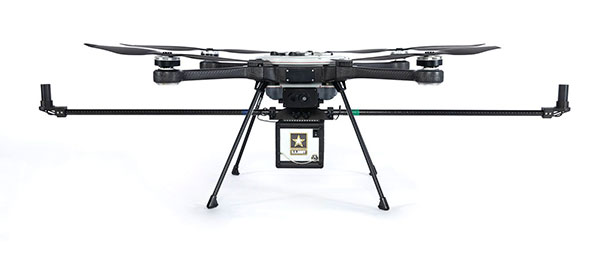
RedTail Lidar RTL-450 integrated onto Teledyne FLIR SkyRaider for tactical operations RedTail Lidar Systems has delivered six lidar systems to the 707th Ordnance Company stationed at Joint Base Lewis-McChord. The systems will provide explosive ordnance disposal (EOD) technicians an opportunity to assess how lidar can be used to enhance their operations. The RedTail Lidar Systems RTL-450 was integrated onto the... read more

This article is tagged with and posted in GIS News, Lidar, Technology

RedTail Lidar Systems demos mapping capability

December 8, 2020By
Top view of lidar point cloud (Image: RedTail Lidar Systems)

RedTail Lidar Systems partnered with an engineering firm to demonstrate the RTL-400 lidar system’s high-resolution, high-accuracy mapping capability. According to the company, its lidar imagery was used to generate as-built conditions of a steep ravine to aid in long-term monitoring of the slopes under which a natural gas pipeline was buried. A narrow road traversing the top of the ravine... read more

3 keys to successful canopy penetration

August 26, 2020By
Photo: RedTail

RedTail Lidar System’s RTL-400 delivers the trifecta Summer is here, and with it comes the challenge of creating accurate topographic maps under tree canopies. The adoption of drone-based, 3D light detection and ranging — or lidar — is emerging as the go-to sensing technique to meet this challenge consistently, safely and cost effectively. Designed specifically for use on small drones,... read more