Your behavior appears to be a little unusual. Please verify that you are not a bot.


TAG: Woolpert

USGS, scientists test drone-based river analysis

June 4, 2019By

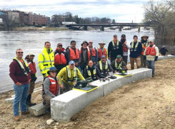
The U.S. Geological Survey (USGS) and independent scientists gathered in Auburn, Maine, to evaluate the use of sensor-mounted unmanned aircraft systems (UAS) to gauge stream stage, velocity, bathymetry and discharge. The technology is being evaluated and modeled to determine whether it will support the fast, accurate and safe measurement of rivers, especially when they are flooded or contain floating trees,... read more

Woolpert contracted by USGS to map, survey throughout US

March 16, 2016By

Woolpert has signed a five-year, multimillion-dollar Geospatial Product and Services Contract 3 (GPSC 3) with the U.S. Geological Survey (USGS) to provide mapping and surveying services. The GPSC is a suite of contracts used by federal, state and municipal government entities to partner with USGS for the purpose of fulfilling their geospatial data requirements. The contract will be administered through... read more

MAPPS presents excellence awards, bestows highest honor to Teledyne Optech

February 5, 2016By
Photo: MAAPS

Teledyne Optech‘s ALTM Titan lidar sensor earned the 2015 Grand Award in the ninth annual MAPPS Geospatial Products and Services Excellence Awards, MAPPS recently announced in a news release. The awards ceremony was held Feb. 2 at the Green Valley Ranch in Henderson, Nev. Teledyne was also presented with an award in the Technology Innovation category. The company said in a news release that... read more

Woolpert-KZF joint venture to build Corps of Engineers complex

January 27, 2016By

The Japan District of the U.S. Army Corps of Engineers has awarded the Woolpert-KZF Joint Venture (W-KZF JV) three task orders totaling approximately $6.95 million to support the design of a $150 million CV-22 complex at Yokota Air Base in Fussa, Japan. The facilities, which will support the bed-down of CV-22 Osprey aircraft at the base, include an aircraft maintenance... read more

This article is tagged with , , and posted in GIS News

USGS Selects Woolpert to Evaluate Lidar for 3DEP

August 13, 2015By

The U.S. Geological Survey (USGS) has contracted with Woolpert to evaluate new lidar (light detection and ranging) technologies to assess the suitability to support the 3D Elevation Program (3DEP). This use of the single photon and Geiger mode lidar for this evaluation is new to the commercial market, according to Woolpert Project Director John Gerhard. “This technology provides the ability to fly... read more