
Trimble deploys custom Applanix positioning system for autonomy
June 17, 2022
Customizable system provides robust positioning without added site infrastructure for IHI Corp. Trimble has announced the first deployment […]
Read More
Customizable system provides robust positioning without added site infrastructure for IHI Corp. Trimble has announced the first deployment […]

GPS positioning for navigation and mapping is challenging in urban environments, where GPS signals often are blocked by […]

Tokyo-based Kudan Inc. demonstrated the use of a 3D-lidar simultaneous localization and mapping (SLAM) device to create a […]

Team Provides Accurate 3D Maps for Smart City Applications According to 2019 statistics, more than 10,000 residential buildings […]
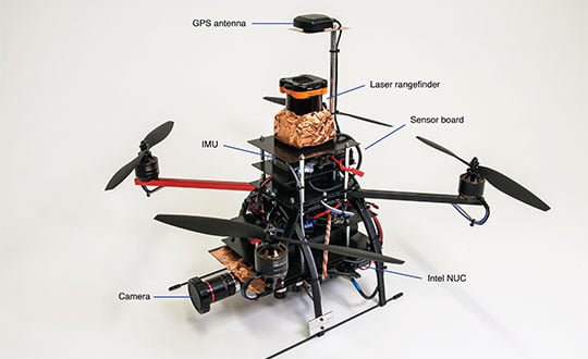
Getting the Best in Both WorldsGPS alone won’t cut it. Thankfully, other navigation sensors can be used to supplement or replace GNSS when the going gets tough for GPS alone.
SLAM-based mobile mapping with integrated 360° color is a rugged, geo-enabled, high-density and versatile workhorse Kaarta, an innovator […]
The latest software release for the SLAM-based NavVis M6 Indoor Mobile Mapping System (IMMS) automatically detects and removes point cloud […]

Q: How can positioning technology ensure safety for passengers of autonomous cars and for others on or near […]


Follow Us