USGS, scientists test drone-based river analysis
June 4, 2019
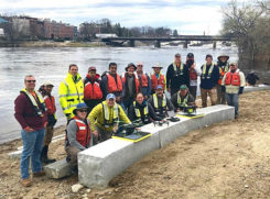
The U.S. Geological Survey (USGS) and independent scientists gathered this month in Auburn, Maine, to evaluate the use […]
Read More
The U.S. Geological Survey (USGS) and independent scientists gathered this month in Auburn, Maine, to evaluate the use […]
Part 1 In a rare historic moment, Congress understood geospatial technology’s important role would be key to support […]
U.S. researchers have completed the first high-resolution, comprehensive mapping of one of the fastest moving underwater tectonic faults […]

An Esri Storymap provides a quick snapshot of the raging fires across the United States and provides context […]

High-resolution lidar surveys help first responders, scientists and government agencies monitor Kilauea conditions and predict future lava flows. […]
Esri has published its latest book, “GIS for Surface Water: Using the National Hydrography Dataset,” by Jeff Simley, […]
The U.S. Geological Survey (USGS) has selected Dewberry, a privately held professional services firm, to collect and process […]

GPS measurements are playing a key role in monitoring the erupting Kilauea volcano in Hawaii. The floor of […]


Follow Us